


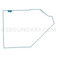
Voting District 1155392000001, Monroe County, Michigan
About
Outline

Summary
| Unique Area Identifier | 598379 |
| Name | Voting District 1155392000001 |
| County | Monroe County |
| State | Michigan |
| Area (square miles) | 2.21 |
| Land Area (square miles) | 2.16 |
| Water Area (square miles) | 0.05 |
| % of Land Area | 97.59 |
| % of Water Area | 2.41 |
| Latitude of the Internal Point | 42.07773800 |
| Longtitude of the Internal Point | -83.68517280 |
Maps

Graphs
Select a template below for downloading or customizing gragh for Voting District 1155392000001, Monroe County, Michigan


Neighbors
Neighoring Voting District (by Name) Neighboring Voting District on the Map
- Voting District 1155390000001, Monroe County, MI
- Voting District 1615392000001W, Washtenaw County, MI
- Voting District 1618910000001, Washtenaw County, MI
Top 10 Neighboring County Subdivision (by Population) Neighboring County Subdivision on the Map
- York charter township, Washtenaw County, MI (8,708)
- Milan city, Washtenaw County, MI (3,770)
- Milan city, Monroe County, MI (2,066)
- Milan township, Monroe County, MI (1,601)
Top 10 Neighboring Place (by Population) Neighboring Place on the Map
Top 10 Neighboring Unified School District (by Population) Neighboring Unified School District on the Map
Top 10 Neighboring State Legislative District Lower Chamber (by Population) Neighboring State Legislative District Lower Chamber on the Map
Top 10 Neighboring State Legislative District Upper Chamber (by Population) Neighboring State Legislative District Upper Chamber on the Map
Top 10 Neighboring 111th Congressional District (by Population) Neighboring 111th Congressional District on the Map
Top 10 Neighboring Census Tract (by Population) Neighboring Census Tract on the Map
- Census Tract 4222, Washtenaw County, MI (7,015)
- Census Tract 4211, Washtenaw County, MI (3,770)
- Census Tract 8307, Monroe County, MI (3,665)